


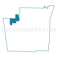
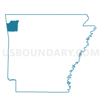
WEDINGTON Voting District, Washington County, Arkansas
About
Outline

Summary
| Unique Area Identifier | 528387 |
| Name | WEDINGTON Voting District |
| County | Washington County |
| State | Arkansas |
| Area (square miles) | 27.03 |
| Land Area (square miles) | 26.75 |
| Water Area (square miles) | 0.28 |
| % of Land Area | 98.97 |
| % of Water Area | 1.03 |
| Latitude of the Internal Point | 36.08800630 |
| Longtitude of the Internal Point | -94.40890580 |
Maps

Graphs
Select a template below for downloading or customizing gragh for WEDINGTON Voting District, Washington County, Arkansas


Neighbors
Neighoring Voting District (by Name) Neighboring Voting District on the Map
- Voting District 013, Benton County, AR
- Voting District 016, Benton County, AR
- ILLINOIS Voting District, Washington County, AR
- LITTERAL Voting District, Washington County, AR
- MARS HILL Voting District, Washington County, AR
- RHEAS MILL Voting District, Washington County, AR
- WHEELER Voting District, Washington County, AR
Top 10 Neighboring County Subdivision (by Population) Neighboring County Subdivision on the Map
- Township 13, Benton County, AR (13,230)
- Litteral township, Washington County, AR (1,500)
- Wheeler township, Washington County, AR (1,398)
- Marrs Hill township, Washington County, AR (1,003)
- Illinois township, Washington County, AR (853)
- Rheas Mill township, Washington County, AR (569)
- Wedington township, Washington County, AR (471)
Top 10 Neighboring Unified School District (by Population) Neighboring Unified School District on the Map
- Siloam Springs Schools, AR (21,753)
- Farmington School District, AR (11,015)
- Prairie Grove School District, AR (9,100)
- Lincoln School District, AR (7,060)
Top 10 Neighboring State Legislative District Lower Chamber (by Population) Neighboring State Legislative District Lower Chamber on the Map
- State House District 100, AR (36,953)
- State House District 97, AR (34,766)
- State House District 87, AR (30,579)
Top 10 Neighboring State Legislative District Upper Chamber (by Population) Neighboring State Legislative District Upper Chamber on the Map
Top 10 Neighboring 111th Congressional District (by Population) Neighboring 111th Congressional District on the Map
Top 10 Neighboring Census Tract (by Population) Neighboring Census Tract on the Map
- Census Tract 105.06, Washington County, AR (9,459)
- Census Tract 105.04, Washington County, AR (7,102)
- Census Tract 213.01, Benton County, AR (6,518)